27 November 2009
The day after Thanksgiving. Reintegrating into society. Had a lovely dinner with a group of people yesterday who knew I hiked the trail. Yet, not a single question was asked or comment given. At the same time, congratulations are pouring in from around the world.
From such a major undertaking and acheivement, many lessons are learned. Some now, others in the future.
To share the adventure with other hikers, people in the trail towns, blog readers, Trail Angels, family and friends has been my honor.
Thank you to all who supported me in so many different ways, your thoughts and actions are appreciated much more than you realize.
Mark "Country Runner" Fromm
Teaneck, NJ (USA)
Friday, November 27, 2009
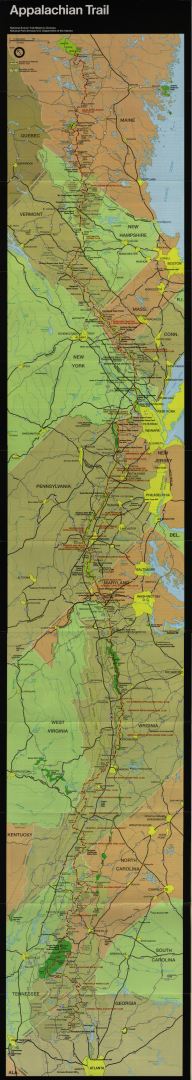
A.T. Trail Statistics
Miles hiked on the Appalachian Trail: 2,178.3
Total miles hiked including side trails: 2,211.2
End Pack Weight: 33 pounds
Starting Body Weight: 163 pounds
Ending Body Weight: 148 pounds
Total Days: 157
Zero Days: 16
Average Miles: 14.08
Average Miles (without zero's): 15.68
Average AT Miles/Day: 13.87
Average AT Miles (without zero's): 15.45
Longest Day: 26.6 miles on 23 September 2009
Position number (SOBO 2009)
Mt. Katadhin: ~100
Harpers Ferry, WV: 43
Amicalola Falls: 41
Some overall stats from the ATC website (as of November 2009):
Southbound thru-hikers at -
Mt. Katadhin: 214
Harpers Ferry: 107
Springer Mtn: still counting…
Thru-hiker completion rate: around 25%
Source: http://www.appalachiantrail.org/site/c.mqLTIYOwGlF/b.4805579/k.DA92/2000Milers_Facts_and_Statistics.htm
The Final Day... It's all in the Journey
21 November 2009
Just a short day's hike from the Hawk Mountain Shelter. At the shelter last night, Krammin's parents showed up and cooked us a steak dinner, potatoes, and served several desserts. Great Trail Magic, Thanks!
At the fire road parking lot 1 mile north of the trail terminus, several groups of family members were assembled to meet the successful thru-hikers. Sisyphus (back right in picture) drove up from Atlanta to pick me up. We had hiked together in Maine and through the White Mountains. PI's parents came to get a photo of him making that "final thru-hike step". Zombie's family showed up with camera's, gifts, and a bottle of well deserved champagne.

Trails end, the view from Springer Mountain

Atop the official plaque (there is a trail register cut into the rock!)

The Last Blaze

Trail Plaque (but it should read "Maine to Georgia")

Official Trail Terminus

The feeling among the hikers on reaching the end of the trail was "so this is it?". A bit less emotional than anticipated. Thus, another of the trail's many lessons... It's all in the Journey, not the Destination.


Blood Mountain
19 November 2009
One of the last nights on the trail. Only 30 miles from Springer Mountain. The group of southbound hikers (SOBO's) is compressing. They are thinking of Thanksgiving at home, hot showers, warm beds, and time with the family.
Tonight we had a large group (by SOBO standards) in the Blood Mountain Shelter, just south (and up a big hill) from Neels Gap. For the NOBO's, many decide the trail is "not for them" at the outfitter in Neels Gap. For many others, the outfitter guides them to more appropriate gear than they may have started out with.
There is an old CCC built shelter from the 1930's on the top of Blood Mtn., and some large rocks atop which one can get great views. Our group talked and watched a superb sunset in the evening, as well as a stunning sunrise the next morning.
The group (L to R: Kramming, Country Runner, Smokey's Friend, PI):

Sunset:


One of the last nights on the trail. Only 30 miles from Springer Mountain. The group of southbound hikers (SOBO's) is compressing. They are thinking of Thanksgiving at home, hot showers, warm beds, and time with the family.
Tonight we had a large group (by SOBO standards) in the Blood Mountain Shelter, just south (and up a big hill) from Neels Gap. For the NOBO's, many decide the trail is "not for them" at the outfitter in Neels Gap. For many others, the outfitter guides them to more appropriate gear than they may have started out with.
There is an old CCC built shelter from the 1930's on the top of Blood Mtn., and some large rocks atop which one can get great views. Our group talked and watched a superb sunset in the evening, as well as a stunning sunrise the next morning.
The group (L to R: Kramming, Country Runner, Smokey's Friend, PI):


Tail of the Dragon
In the area of Fontana Dam Village, there are many posters advertising the "Tail of the Dragon". It turns out that there is a winding country road nearby where drivers who want to "push the limits" drive their vehicles - mainly sports cars and motorcycles.

They describe it this way on the website http://www.tailofthedragon.com/:

"TAIL OF THE DRAGON AT DEALS GAP, with 318 curves in 11 miles, is America's number one motorcycle and sports car road. The nearby CHEROHALA SKYWAY is quickly becoming number two with its remote 60 miles of scenic mountain highway. The area also has other incredible roads like the DEVILS TRIANGLE, THE SNAKE, BLOOD MOUNTAIN, MOONSHINER 28 and some GREAT DUAL SPORT RIDING."


Thursday, November 26, 2009
Food? No food! ... and a Trail Angel
11 November 2009
After several days in the Smokies, my food was low (as planned). Hiked across Fontana Dam and into Fontana Village. Being late in the year, and past the main tourist season, many of the services listed in my guide book are closed. Even the restaurant in the resort hotel is only open on the weekend. The General Store, the Outfitter... all closed! While talking with the employee at the check-in desk, a man overheard my predicament. He said "why don't you come to my cabin? My wife has some soup left over from dinner". Not being in a position to refuse, I accepted. Robert and Margie (as well as their son Mike) from Luck, WI took me in and fed me. They had no idea people thru-hiked the Appalachian Trail or what Trail Angels are. There they were, feeding me and becoming Trail Angels on the spot! They enjoyed hearing stories about trail life, and even invited me back for breakfast. The following morning we had a nice breakfast together and before my departure they gave me apples, nuts, and a sandwich. All very fortunate since hiking on an empty stomach is pretty tough while burning through 4-5,000 calories a day. Thank you all Trail Angels!!
After several days in the Smokies, my food was low (as planned). Hiked across Fontana Dam and into Fontana Village. Being late in the year, and past the main tourist season, many of the services listed in my guide book are closed. Even the restaurant in the resort hotel is only open on the weekend. The General Store, the Outfitter... all closed! While talking with the employee at the check-in desk, a man overheard my predicament. He said "why don't you come to my cabin? My wife has some soup left over from dinner". Not being in a position to refuse, I accepted. Robert and Margie (as well as their son Mike) from Luck, WI took me in and fed me. They had no idea people thru-hiked the Appalachian Trail or what Trail Angels are. There they were, feeding me and becoming Trail Angels on the spot! They enjoyed hearing stories about trail life, and even invited me back for breakfast. The following morning we had a nice breakfast together and before my departure they gave me apples, nuts, and a sandwich. All very fortunate since hiking on an empty stomach is pretty tough while burning through 4-5,000 calories a day. Thank you all Trail Angels!!
Subscribe to:
Posts (Atom)