27 November 2009
The day after Thanksgiving. Reintegrating into society. Had a lovely dinner with a group of people yesterday who knew I hiked the trail. Yet, not a single question was asked or comment given. At the same time, congratulations are pouring in from around the world.
From such a major undertaking and acheivement, many lessons are learned. Some now, others in the future.
To share the adventure with other hikers, people in the trail towns, blog readers, Trail Angels, family and friends has been my honor.
Thank you to all who supported me in so many different ways, your thoughts and actions are appreciated much more than you realize.
Mark "Country Runner" Fromm
Teaneck, NJ (USA)
Friday, November 27, 2009
A.T. Trail Statistics
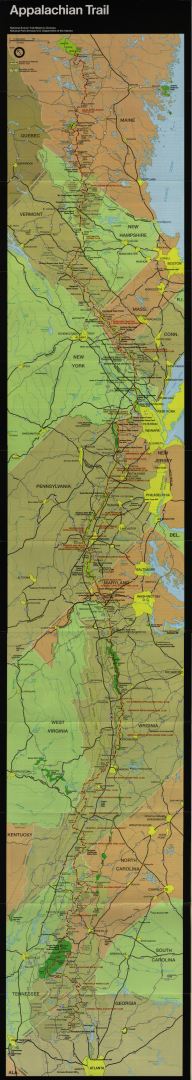
Miles hiked on the Appalachian Trail: 2,178.3
Total miles hiked including side trails: 2,211.2
End Pack Weight: 33 pounds
Starting Body Weight: 163 pounds
Ending Body Weight: 148 pounds
Total Days: 157
Zero Days: 16
Average Miles: 14.08
Average Miles (without zero's): 15.68
Average AT Miles/Day: 13.87
Average AT Miles (without zero's): 15.45
Longest Day: 26.6 miles on 23 September 2009
Position number (SOBO 2009)
Mt. Katadhin: ~100
Harpers Ferry, WV: 43
Amicalola Falls: 41
Some overall stats from the ATC website (as of November 2009):
Southbound thru-hikers at -
Mt. Katadhin: 214
Harpers Ferry: 107
Springer Mtn: still counting…
Thru-hiker completion rate: around 25%
Source: http://www.appalachiantrail.org/site/c.mqLTIYOwGlF/b.4805579/k.DA92/2000Milers_Facts_and_Statistics.htm
The Final Day... It's all in the Journey
21 November 2009
Just a short day's hike from the Hawk Mountain Shelter. At the shelter last night, Krammin's parents showed up and cooked us a steak dinner, potatoes, and served several desserts. Great Trail Magic, Thanks!
At the fire road parking lot 1 mile north of the trail terminus, several groups of family members were assembled to meet the successful thru-hikers. Sisyphus (back right in picture) drove up from Atlanta to pick me up. We had hiked together in Maine and through the White Mountains. PI's parents came to get a photo of him making that "final thru-hike step". Zombie's family showed up with camera's, gifts, and a bottle of well deserved champagne.

Trails end, the view from Springer Mountain

Atop the official plaque (there is a trail register cut into the rock!)

The Last Blaze

Trail Plaque (but it should read "Maine to Georgia")

Official Trail Terminus

The feeling among the hikers on reaching the end of the trail was "so this is it?". A bit less emotional than anticipated. Thus, another of the trail's many lessons... It's all in the Journey, not the Destination.


Blood Mountain
19 November 2009
One of the last nights on the trail. Only 30 miles from Springer Mountain. The group of southbound hikers (SOBO's) is compressing. They are thinking of Thanksgiving at home, hot showers, warm beds, and time with the family.
Tonight we had a large group (by SOBO standards) in the Blood Mountain Shelter, just south (and up a big hill) from Neels Gap. For the NOBO's, many decide the trail is "not for them" at the outfitter in Neels Gap. For many others, the outfitter guides them to more appropriate gear than they may have started out with.
There is an old CCC built shelter from the 1930's on the top of Blood Mtn., and some large rocks atop which one can get great views. Our group talked and watched a superb sunset in the evening, as well as a stunning sunrise the next morning.
The group (L to R: Kramming, Country Runner, Smokey's Friend, PI):

Sunset:


One of the last nights on the trail. Only 30 miles from Springer Mountain. The group of southbound hikers (SOBO's) is compressing. They are thinking of Thanksgiving at home, hot showers, warm beds, and time with the family.
Tonight we had a large group (by SOBO standards) in the Blood Mountain Shelter, just south (and up a big hill) from Neels Gap. For the NOBO's, many decide the trail is "not for them" at the outfitter in Neels Gap. For many others, the outfitter guides them to more appropriate gear than they may have started out with.
There is an old CCC built shelter from the 1930's on the top of Blood Mtn., and some large rocks atop which one can get great views. Our group talked and watched a superb sunset in the evening, as well as a stunning sunrise the next morning.
The group (L to R: Kramming, Country Runner, Smokey's Friend, PI):


Tail of the Dragon
In the area of Fontana Dam Village, there are many posters advertising the "Tail of the Dragon". It turns out that there is a winding country road nearby where drivers who want to "push the limits" drive their vehicles - mainly sports cars and motorcycles.

They describe it this way on the website http://www.tailofthedragon.com/:

"TAIL OF THE DRAGON AT DEALS GAP, with 318 curves in 11 miles, is America's number one motorcycle and sports car road. The nearby CHEROHALA SKYWAY is quickly becoming number two with its remote 60 miles of scenic mountain highway. The area also has other incredible roads like the DEVILS TRIANGLE, THE SNAKE, BLOOD MOUNTAIN, MOONSHINER 28 and some GREAT DUAL SPORT RIDING."


Thursday, November 26, 2009
Food? No food! ... and a Trail Angel
11 November 2009
After several days in the Smokies, my food was low (as planned). Hiked across Fontana Dam and into Fontana Village. Being late in the year, and past the main tourist season, many of the services listed in my guide book are closed. Even the restaurant in the resort hotel is only open on the weekend. The General Store, the Outfitter... all closed! While talking with the employee at the check-in desk, a man overheard my predicament. He said "why don't you come to my cabin? My wife has some soup left over from dinner". Not being in a position to refuse, I accepted. Robert and Margie (as well as their son Mike) from Luck, WI took me in and fed me. They had no idea people thru-hiked the Appalachian Trail or what Trail Angels are. There they were, feeding me and becoming Trail Angels on the spot! They enjoyed hearing stories about trail life, and even invited me back for breakfast. The following morning we had a nice breakfast together and before my departure they gave me apples, nuts, and a sandwich. All very fortunate since hiking on an empty stomach is pretty tough while burning through 4-5,000 calories a day. Thank you all Trail Angels!!
After several days in the Smokies, my food was low (as planned). Hiked across Fontana Dam and into Fontana Village. Being late in the year, and past the main tourist season, many of the services listed in my guide book are closed. Even the restaurant in the resort hotel is only open on the weekend. The General Store, the Outfitter... all closed! While talking with the employee at the check-in desk, a man overheard my predicament. He said "why don't you come to my cabin? My wife has some soup left over from dinner". Not being in a position to refuse, I accepted. Robert and Margie (as well as their son Mike) from Luck, WI took me in and fed me. They had no idea people thru-hiked the Appalachian Trail or what Trail Angels are. There they were, feeding me and becoming Trail Angels on the spot! They enjoyed hearing stories about trail life, and even invited me back for breakfast. The following morning we had a nice breakfast together and before my departure they gave me apples, nuts, and a sandwich. All very fortunate since hiking on an empty stomach is pretty tough while burning through 4-5,000 calories a day. Thank you all Trail Angels!!

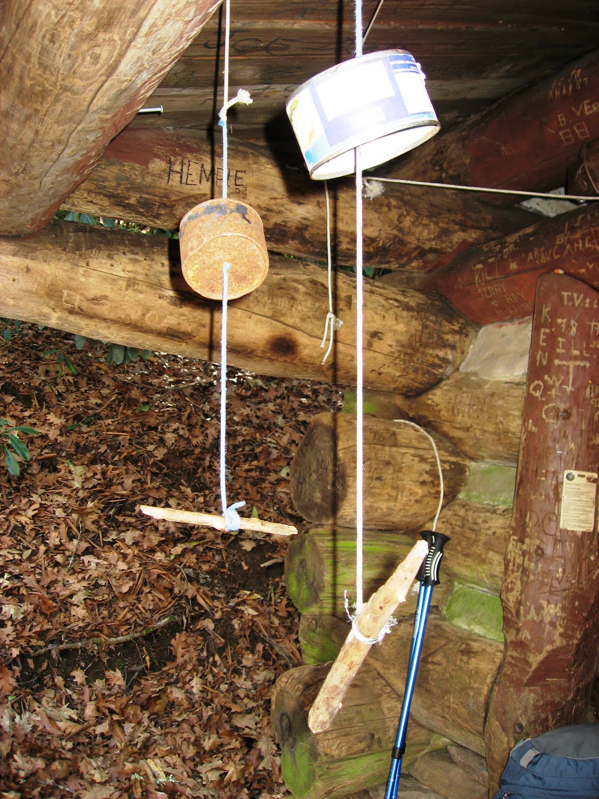
Mice
Especially along the southern part of the Appalachian Trail, it is common to find shelters infested with mice. People seem to leave enough food scraps that they want to live there. If they get hungry enough, they will even eat paper and sometimes the registration books are partly eaten up. To avoid having food eaten by mice during the night, people hang their food bags on a contraption shown here. The mice cannot get down the string and around the upside-down can.

One solution is to carry a few mouse traps. One northbound thru hiker this year got the trail name 10x10 because at one shelter he caught 10 mice before 10pm. He must have been popular with the other hikers!
Some of the southbounders started carrying traps as well. Here is the result of a night's work.

Some of the southbounders started carrying traps as well. Here is the result of a night's work.

Hiking in a Hurricane
10 November 2009
Hurricane IDA hit during my hike of the southern part of the Great Smokey Mountains National Park. The rain came from the southwest and combined with cold wind from the northwest. Since the Appalachian Trail runs along the main ridgeline, it gets hit hard by the weather. Early in the morning the trail climbed to it's highest point of the entire trail, Clingmans Dome. It was all in a cloud with rain blowing almost horizontally. No views today. Passing two other shelters, stopped to see who was there and to check the trail registers. It seems that almost everyone was spending the day holed up. Eventually the wind and rain soaked through my REI raincoat and the shirt underneath. Only hiking fast and hard generated heat enough to keep me out of hypothermia. At the end of the day, reached the Spence Field Shelter. Nobody else there. The signs and trail register warn that the area has high Bear activity. It seems that they like the nuts that fall from the trees surrounding the shelter! Cold and with fingers barely working, I unpack, warm up, and cook dinner. Although the shelter has "bear cables" outside to hang food out of the reach of bears, it is hard for me to envision going outside in the intensifying storm. Any sane bear would stay holed up and wait for better weather before foraging. The storm raged all night and started to pass in the morning. The food had been hung in the shelter away from mice but not bears. Neither got my food during the night. The following morning, put on my cold wet clothes and started hiking.
Hurricane IDA hit during my hike of the southern part of the Great Smokey Mountains National Park. The rain came from the southwest and combined with cold wind from the northwest. Since the Appalachian Trail runs along the main ridgeline, it gets hit hard by the weather. Early in the morning the trail climbed to it's highest point of the entire trail, Clingmans Dome. It was all in a cloud with rain blowing almost horizontally. No views today. Passing two other shelters, stopped to see who was there and to check the trail registers. It seems that almost everyone was spending the day holed up. Eventually the wind and rain soaked through my REI raincoat and the shirt underneath. Only hiking fast and hard generated heat enough to keep me out of hypothermia. At the end of the day, reached the Spence Field Shelter. Nobody else there. The signs and trail register warn that the area has high Bear activity. It seems that they like the nuts that fall from the trees surrounding the shelter! Cold and with fingers barely working, I unpack, warm up, and cook dinner. Although the shelter has "bear cables" outside to hang food out of the reach of bears, it is hard for me to envision going outside in the intensifying storm. Any sane bear would stay holed up and wait for better weather before foraging. The storm raged all night and started to pass in the morning. The food had been hung in the shelter away from mice but not bears. Neither got my food during the night. The following morning, put on my cold wet clothes and started hiking.
Wednesday, November 25, 2009
Bears in Great Smoky Mountains National Park
There are bears, people who want to feed them, and no hunters to thin them out. When the bears get used to hiker food, problems ensue.
There are warning signs.

This is a bag shreded by a bear sitting on top of the shelter a day or so before my stay.

On a related topic, the Standing Bear (hiker) Hostel is located just north of the park. All the basics are provided.

Max Patch
07 November 2009
Max Patch is one of the sections NOBO's always mention as one of their favorites. It was nice to finally see it! As a "bald", there are 360 degree views from the top with mountains as far as the eye can see.


Max Patch is one of the sections NOBO's always mention as one of their favorites. It was nice to finally see it! As a "bald", there are 360 degree views from the top with mountains as far as the eye can see.


Bear Snack
29 October 2009
During the big climb up to Grassy Ridge, the warming sun shone and at 10:30am it seemed to be a good time for a snack. Stopped on the trail, unpacked my food, and started spreading peanut butter on a bagel. While topping it off with honey, a loud rustling noise came from my right. Looked up to see a Black Bear headed directly for me about 100 fee away. He definately smelled the honey. What to do? Looked over at my belongings spread around and decided packing and hiking away quickly was not an option. Then remembered the suggested actions. Stood up to "look big", then started yelling to scare the bear off.
The bear stopped. The bear stood up on his hind legs.. just as I had done. It peered in my direction for a mement, then turned around and quickly moved off on all fours.
Close call! Sorry, no pictures...
Thursday, November 5, 2009
Appalachian Trail - Part 11
Another "Border Crossing"

Watauga Lake from the ridgeline...

Laurel Fork Falls near Kincora Hostel

This reminds me of Japan

Barn converted to Overmountain Shelter for distance hikers (and mice)

These friendly folks have served (excellent) free meals to 2,000 hikers over the years. Already thru hikers themselves, they offer books on Christianity to those who are looking for information and direction in their lives.


Grassy Ridge/Carvers Gap Area. This is a "Bald" with excellent views.

Favorite trail photo of myself.

Another border... not many left!


Hiking in the Clouds

Friday, October 23, 2009
Presently in Damascus, VA
Tomorrow will cross the border to TN.
So far 1,715.3 miles have been completed, 463.0 to go.
So far 1,715.3 miles have been completed, 463.0 to go.


Grayson Highlands - my 2nd Favorite day on the trail
20 October 2009
A cold night last night. Up in time to watch first light and sunrise through the trees. More SOBO's around now as the group compresses. These are the folks who are intending to be home in time for Thanksgiving. They are going to finish and know it. A perfect weather day for hiking. Ledge and Zombie hike with me for part of the day. The trail climbed to 5,000 feet and stayed there. Soon, it enters Grayson Highlands State Park. The area is popular with horseback riders and a group is just setting off for a ride. There are also "wild horses" roaming around. Lots of fields, old roads, and trails. For me, this is perfect trail running country and brings back memories of other excellent runs. It would be easy to run here for hours. At the end of the day, reached the Thomas Knob Shelter. Behind are some rocks where it is easy to relax and cook dinner. Several hikers ate dinner as the sun set spectacularly with colors including red, orange, and blue. Decided to camp nearby for the night.


Winter is coming on the Appalchian Trail
23 October 2009
First Snow! Cold Nights! Happy to have my nice warm down sleeping bag back. On the positive side, the cool weather makes for perfect hiking. The trees are colorful, and as the leaves fall, the views come more often. Here is a nice section of trail just after the snow fell.

First Snow! Cold Nights! Happy to have my nice warm down sleeping bag back. On the positive side, the cool weather makes for perfect hiking. The trees are colorful, and as the leaves fall, the views come more often. Here is a nice section of trail just after the snow fell.

Mice!!!
23 October 2009
Checked into this lovely shelter after a day of hiking. All seemed good, a well inclosed shelter on a cold night. Then, during the night there were rustling sounds and the pitter patter of many small feet. Our shelter was highly infested with agressive shelter mice! They even chewed through bags that had no food in them!
Time to start using the tent again!

Time to start using the tent again!
Hiker Hostel's
After nights in the woods, a Hiker Hostel or Hiker B&B is much appreciated. The owners are always friendly, and make extra efforts so their guests feel at home. No standard sanitized hotel rooms here! Some examples are the Dutch Haus B&B http://www.dutchhaus.com/,
Woods Hole - now run by Neville and thru-hiker Michael (Neville is the Granddaughter of the founder), where the buildings date from the late 1800's and are made of Chestnut logs,


The Happy Hiker (owners Rambunny and Aqua have a total of 10,000 hiking miles between them),

and The Hiker Inn in Damascus, VA where owner Suzzane really goes out of her way for her guests.
Subscribe to:
Posts (Atom)